Bibliography for Websites
Websites in correct bibliography order
BBC News, 2012. Japan quake: Loss and recovery in numbers.
[online] Available at: <http://www.bbc.com/news/world-asia-17219008>
[Accessed 12 Nov. 2015].
Evaluation: Good source, that supplied number on property damages as
well as death toll.
Bernard, E. and Titov, V., 2015. Evolution of tsunami warning
systems and products. Phil. Trans. R. Soc. A, 373(2053), p.20140371.
Evaluation: Showed how recent tsunamis have led to revival in the
science.
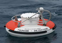
Bom.gov.au, 2015. Deep Ocean Tsunami Detection Buoys.
[online] Available at:
<http://www.bom.gov.au/tsunami/about/detection_buoys.shtml> [Accessed 26
Nov. 2015].
Evaluation: Information on current warning systems for Tsunamis.
Bom.gov.au, 2015. Tsunami Facts and Information. [online]
Available at: <http://www.bom.gov.au/tsunami/info/> [Accessed 26 Nov.
2015].
Evaluation: More information on how tsunami wave heights can be
calculated and what apparatus is used.
Brave New Climate, 2011. Fukushima Nuclear Accident - a simple
and accurate explanation. [online] Available at:
<http://bravenewclimate.com/2011/03/13/fukushima-simple-explanation/>
[Accessed 15 Nov. 2015].
Evaluation: Informative source on Fukushima nuclear disaster and its
impacts.
Cluff, L., 2007. NAE Website
- Effects of the 2004 Sumatra-Andaman Earthquake and Indian Ocean
Tsunami in Aceh Province. [online] Nae.edu. Available at: <https://www.nae.edu/Publications/Bridge/EngineeringfortheThreatofNaturalDisasters/Effectsofthe2004Sumatra-AndamanEarthquakeandIndianOceanTsunamiinAcehProvince.aspx>
[Accessed 25 Nov. 2015].
Evaluation: Detail analysis of the impacts and damage of the
earthquake and tsunami and was extremely helpful.
Faust, T., 2005. Indian Ocean Earthquake Triggers Deadly Tsunami.
[online] Soundwaves.usgs.gov. Available at:
<http://soundwaves.usgs.gov/2005/01/> [Accessed 25 Nov. 2015].
Evaluation: Sourced used to give information on tectonics for the
2004 disaster.
Kageyama, Y., 2015. Child cancer rate soars after Fukushima
nuclear disaster | Toronto Star. [online] thestar.com. Available at:
<http://www.thestar.com/news/world/2015/10/08/child-cancer-rate-soars-after-fukushima-nuclear-disaster.html>
[Accessed 23 Nov. 2015].
Evaluation: Good source at showing the ongoing impacts of the
disaster of 2011.
Lee, J., 2013. The 2011 Japan Tsunami Was Caused By Largest Fault
Slip Ever Recorded. [online] News.nationalgeographic.com. Available at:
<http://news.nationalgeographic.com/news/the-2011-japan-tsunami-was-caused-by-largest-fault-slip-ever-recorded/>
[Accessed 2 Nov. 2015].
Evaluation: Describe the massive fault slip that occurred during the
2004 earthquake.
National Geographic Education, 2011. Ring of Fire. [online]
Available at: <http://education.nationalgeographic.com.au/encyclopedia/ring-fire/>
[Accessed 2 Nov. 2015].
Evaluation: Wwas used as background information for the Japanese
earthquake and explains why the area is so dynamic.
Nguyen, T., 2014. This House is Built to Withstand the Force of a
Tsunami. [online] Smithsonian. Available at:
<http://www.smithsonianmag.com/innovation/house-built-withstand-force-tsunami-180949455/?no-ist>
[Accessed 26 Nov. 2015].
Evaluation: Great source that demonstrates the type of tsunami resistant
infrastructure that can be developed.
Oskin, B., 2015. Japan Earthquake & Tsunami of 2011: Facts
and Information. [online] LiveScience.com. Available at:
<http://www.livescience.com/39110-japan-2011-earthquake-tsunami-facts.html>
[Accessed 3 Nov. 2015].
Evaluation: Great information on the mechanics as well as the
affects of the 2011 Japanese earthquake and tsunami
Pike, J., 2015. Japan Tsunami Damage Cost Could Top $300 Billion.
[online] Globalsecurity.org. Available at:
<http://www.globalsecurity.org/wmd/library/news/japan/2011/japan-110325-voa01.htm>
[Accessed 17 Nov. 2015].
Evaluation: Talks of the massive costs that were as a result of the
tsunami that destroyed complete areas of Japan.
Rafferty, J. and Pletcher, K., 2015. Japan earthquake and tsunami
of 2011. [online] Encyclopedia Britannica. Available at:
<http://www.britannica.com/event/Japan-earthquake-and-tsunami-of-2011>
[Accessed 2 Nov. 2015].
Evaluation: Favourite site that was used, informative and detailed
that gave information on almost all aspects of the 2011 tectonic disaster
Sample, I., 2011. Japan earthquake and tsunami: what happened and
why. [online] the Guardian. Available at:
<http://www.theguardian.com/world/2011/mar/11/japan-earthquake-tsunami-questions-answers>
[Accessed 2 Nov. 2015].
Evaluation: One of many sites that used when getting background
information on the Japan disaster.
Evaluation: Report on wave heights in the area of Sumatra used for
research of the mechanics of the 2004 event
The Washington Post, 2011. Japan a leader in engineering
earthquake-proof structures, helping to limit damage. [online] Available
at: <http://www.washingtonpost.com/wp-dyn/content/article/2011/03/11/AR2011031104541_2.html>
[Accessed 26 Nov. 2015].
Evaluation: Was used for the majority of information on the
earthquake resistant buildings and was highly helpful
USGS, 2014. Monitoring Instruments. [online] Available at:
<http://earthquake.usgs.gov/monitoring/deformation/data/instruments.php>
[Accessed 26 Nov. 2015].
Evaluation: Used for research into instruments used to record and
warn people of earthquakes.
Wikipedia, 2005. 2004 Indian Ocean earthquake and tsunami.
[online] Available at:
<https://en.wikipedia.org/wiki/2004_Indian_Ocean_earthquake_and_tsunami>
[Accessed 24 Nov. 2015].
Evaluation: Proved to be one of the best source due to the depth
that it had on all areas affected by the disaster and was used for a large
portion of the report on the Indian Ocean disaster.
YouTube, 2011. Japan's Tsunami: How It Happened (1 of 5).
[online] Available at: <https://www.youtube.com/watch?v=3FM4E19PZhw>
[Accessed 2 Nov. 2015].
YouTube, 2011. Japan's Tsunami: How It Happened (2 of 5).
[online] Available at: <https://www.youtube.com/watch?v=8Yx3nK7si-Q>
[Accessed 2 Nov. 2015].
YouTube, 2011. Japan's Tsunami: How It Happened (3 of 5).
[online] Available at: <https://www.youtube.com/watch?v=TLpZOAdZsDg>
[Accessed 2 Nov. 2015].
YouTube, 2011. Japan's Tsunami: How It Happened (4 of 5).
[online] Available at: <https://www.youtube.com/watch?v=D_54UJ2msC0> [Accessed
2 Nov. 2015].
YouTube, 2011. Japan's Tsunami: How It Happened (5 of 5).
[online] Available at: <https://www.youtube.com/watch?v=Ww4ozXrBxY4>
[Accessed 2 Nov. 2015].
Evaluation of video parts 1 to 5: A great resource to orientate yourself
on the issues that are caused by such tectonic events and was able to obtain a
rough understanding of the timeline events from the 2011 disaster.
YouTube, 2013. Understanding the accident of Fukushima Daiichi
NPS - Source IRSN. [online] Available at:
<https://www.youtube.com/watch?v=JMaEjEWL6PU> [Accessed 12 Nov. 2015].
Evaluation: Gave an in depth walk through of the Fukushima Daiichi
Nuclear Disaster and what occurred
YouTube, 2015. Fukushima
Nuclear Reactor Problem Explained (CNN). [online] Available at:
<https://www.youtube.com/watch?v=BdbitRlbLDc> [Accessed 13 Nov. 2015].
Evaluation: Was
also used to understand the Fukushima Daiichi Nuclear Disaster and the events
that unfolded
Image order from first to last post in
order of appearance – as image are un able to be referenced in the blog
themselves
Photo from Website: Encyclopedia Britannica, 2011. Japan
earthquake and tsunami of 2011. [online] Available at:
<http://www.britannica.com/event/Japan-earthquake-and-tsunami-of-2011>
[Accessed 2 Nov. 2015].
Evaluation: Good images that show an accurate location of the epicentre.
Ted-Ed, 2014. How tsunamis work - Alex Gendler. [video]
Available at: <https://www.youtube.com/watch?v=Wx9vPv-T51I> [Accessed 16
Nov. 2015].
Evaluation:
Great short explanation of how a tsunami works.
Australian Geographic, 2011. A tsunami hits the north-east coast
of Japan after a magnitude 9.0 earthquake on March 11, 2011.. [image]
Available at:
<https://www.google.com.au/search?q=japan+tsunami+hits+coast&espv=2&biw=1440&bih=778&tbm=isch&imgil=2z4h7oo4WGQpjM%253A%253BpcRg3_8NdedO8M%253Bhttp%25253A%25252F%25252Fwww.foxnews.com%25252Fworld%25252F2011%25252F03%25252F11%25252Ftsunami-watch-issued-hawaii-pacific%25252F&source=iu&pf=m&fir=2z4h7oo4WGQpjM%253A%252CpcRg3_8NdedO8M%252C_&dpr=1&usg=__qbECBs-NzpAHj9pbdpbv9OYcejc%3D&ved=0ahUKEwiz6auTjq7JAhVn3KYKHZDuAYsQyjcINg&ei=0P1WVrPBL-e4mwWQ3YfYCA&safe=active&ssui=on#imgrc=Mh5I-tZaaYHEPM%3A&usg=__qbECBs-NzpAHj9pbdpbv9OYcejc%3D>
[Accessed 25 Nov. 2015].
Evaluation: Powerful image that shows the force of the Tsunami as
it crashes through Japan
Getty Images, 2011. https://www.google.com.au/search?q=fukushima+explosion&source=lnms&tbm=isch&sa=X&ved=0ahUKEwjgw6vGya7JAhWDKaYKHelBD78Q_AUICCgC&biw=1440&bih=918&safe=active&ssui=on#imgrc=lKLIZeqA99JAlM%3A.
[image] Available at:
<https://www.google.com.au/search?q=fukushima+explosion&source=lnms&tbm=isch&sa=X&ved=0ahUKEwjgw6vGya7JAhWDKaYKHelBD78Q_AUICCgC&biw=1440&bih=918&safe=active&ssui=on#imgrc=lKLIZeqA99JAlM%3A>
[Accessed 26 Nov. 2015]
Evaluation: Shows the explosion of radioactive material and is a
visual aid to the explanation used in the blog and hence is helpful
Getty Images, 2011. A ship washed ashore during the 2011 Japan
tsunami lies amidst wreckage in Kesennuma, Miyagi, Japan.. [image]
Available at:
<https://www.google.com.au/search?q=japan+tsunami+hits+coast&espv=2&biw=1440&bih=778&tbm=isch&imgil=2z4h7oo4WGQpjM%253A%253BpcRg3_8NdedO8M%253Bhttp%25253A%25252F%25252Fwww.foxnews.com%25252Fworld%25252F2011%25252F03%25252F11%25252Ftsunami-watch-issued-hawaii-pacific%25252F&source=iu&pf=m&fir=2z4h7oo4WGQpjM%253A%252CpcRg3_8NdedO8M%252C_&dpr=1&usg=__qbECBs-NzpAHj9pbdpbv9OYcejc%3D&ved=0ahUKEwiz6auTjq7JAhVn3KYKHZDuAYsQyjcINg&ei=0P1WVrPBL-e4mwWQ3YfYCA&safe=active&ssui=on#safe=active&tbm=isch&q=damage+to+property+due+to+tsunai+japan+2011&imgrc=fM3bkZKFwSr18M%3A>
[Accessed 26 Nov. 2015].
Evaluation: Shows the power of the tsunami to be able to carry a
tanker inland
Shimbun, A., 2011. A woman cries while sitting on a road amid the
destroyed city of Natori, Miyagi Prefecture in northern Japan March 13, 2011..
[image] Available at:
<http://in.reuters.com/article/2011/03/14/idINIndia-55567920110314>
[Accessed 26 Nov. 2015].
Evaluation: The anguish on the women face show the distress she is
in due to the disaster.
Evaluation: Good map at showing all the different places that were
affect by the 2004 tsunami
Russian Academy of Science, 2005. The Global Reach of the 26
December 2004 Sumatra Tsunami. [image] Available at:
<https://www.google.com.au/search?q=japan+tsunami+hits+coast&espv=2&biw=1440&bih=778&tbm=isch&imgil=2z4h7oo4WGQpjM%253A%253BpcRg3_8NdedO8M%253Bhttp%25253A%25252F%25252Fwww.foxnews.com%25252Fworld%25252F2011%25252F03%25252F11%25252Ftsunami-watch-issued-hawaii-pacific%25252F&source=iu&pf=m&fir=2z4h7oo4WGQpjM%253A%252CpcRg3_8NdedO8M%252C_&dpr=1&usg=__qbECBs-NzpAHj9pbdpbv9OYcejc%3D&ved=0ahUKEwiz6auTjq7JAhVn3KYKHZDuAYsQyjcINg&ei=0P1WVrPBL-e4mwWQ3YfYCA&safe=active&ssui=on#safe=active&tbm=isch&q=tidal+gauges+level+tsunami+2004&imgrc=crsQwQXyw8SlTM%3A>
[Accessed 24 Nov. 2015].
Evaluation: Shows the dispersion of water through out the Indian
ocean effectively.
BBC, 2014. Boxing Day tsunami 2004: How the places affected look
now. [image] Available at:
<http://www.abc.net.au/news/2014-12-24/boxing-day-tsunami-then-now-photos/5875900>
[Accessed 25 Nov. 2015].
Evaluation: Good comparision of the rebuild that was undertaken in
the area hit in 2004
Evaluation: Shows the apparatus used
for detecting Earthquakes.